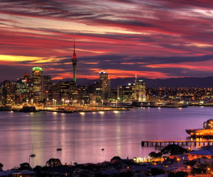
Waitemata Harbour
NewZealandAirport.com »
New Zealand Tourism » Waitemata Harbour

Waitematā Harbour is the main access by sea to Auckland, New Zealand. For
this reason it is often referred to as Auckland Harbour, despite the fact that
it is one of two harbours adjoining the city.
The harbour forms the northern and eastern coasts of the Auckland isthmus and is
crossed by the Auckland Harbour Bridge. It is matched on the southern side of
the city by the shallower waters of the Manukau Harbour.
With an area of 70 square miles (180 km2), it connects the city's main port and
the Auckland waterfront to the Hauraki Gulf and the Pacific Ocean. It is
sheltered from Pacific storms by Auckland's North Shore, Rangitoto Island, and
Waiheke Island. The harbour is an arm of the Hauraki Gulf, extending west for
eighteen kilometres from the end of the Rangitoto Channel.
Its entrance is between North Head and Bastion Point in the south. The
westernmost ends of the harbour extend past Whenuapai in the northwest, and to
Te Atatu in the west, as well as forming the estuarial arm known as the Whau
River in the southwest.
Getting There
This tourist attraction is well serviced by public transport including taxis,
buses and shuttle.
folder_open New Zealand Tourism