Nelson Lakes National Park
NewZealandAirport.com »
New Zealand Tourism » Nelson Lakes National Park
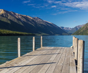
TNelson Lakes National Park is located in the South Island of New Zealand.
It was formed in 1956 and covers some 1,019 square kilometres (393 sq mi).
It is centered at two large lakes, Rotoiti and Rotoroa. The park also includes
surrounding valleys (including Travers, Sabine, and D'Urville, upper reaches of
the Matakitaki) and mountain ranges (Saint Arnaud Range, Mount Robert). The park
is a popular area for camping, tramping and fishing.
The park is administered by the Department of Conservation who operate a
Visitors Centre in Saint Arnaud that provides up to date and reliable
information on all aspects of the National Park. The main campgrounds are on the
shores of Lake Rotoiti; there is a smaller campground at Lake Rotoroa.
There is a network of tramping tracks throughout the park. Tracks range from
short nature walks at Lake Rotoiti and Lake Rotorua, to multi-day backcountry
tramps. Day tramps include the Lake Rotoiti circuit, St. Arnaud Range and Mt.
Robert. The most popular long-distance tramping routes are the Travers-Sabine
Circuit and other loops through Lake Angelus.
The skifield on Mt. Robert is no longer operational. Rainbow Ski Area is located
on the eastern side of the St Arnaud range, just outside the park.
Other activities include mountaineering, boating and fishing, and mountain
biking. See the DOC web site for more information.
Getting There
The main access point to Nelson Lakes National Park is at Lake Rotoiti and the
village of Saint Arnaud, on Highway 63, about 100 kilometres from both Nelson
and Blenheim. A secondary access point is at Lake Rotoroa, turning off New
Zealand State Highway 6 at Gowanbridge. Shuttle services operate between St
Arnaud, Nelson, Blenheim and Picton.
folder_open New Zealand Tourism