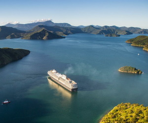
Marlborough Sounds
NewZealandAirport.com »
New Zealand Tourism » Marlborough Sounds

The Marlborough Sounds are an extensive network of sea-drowned valleys at
the northern end of the South Island of New Zealand. The Marlborough Sounds were
created by a combination of land subsidence and rising sea levels.
According to Māori mythology, the sounds are the prows of the sunken wakas of
Aoraki. Covering some 4,000 km2 (1,500 sq mi) of sounds, islands, and
peninsulas, the Marlborough Sounds lie at the South Island's north-easternmost
point, between Tasman Bay in the west and Cloudy Bay in the south-east. The
almost fractal coastline has 1/5 of the length of New Zealand's coasts.
The steep, wooded hills and small quiet bays of the sounds are sparsely
populated, as access is difficult.
Many of the small settlements and isolated houses are only accessible by boat.
The main large port is Picton on the mainland, at the head of Queen Charlotte
Sound. It is at the northern terminus of the South Island's main railway and
state highway networks. The main small-boat port, Waikawa, is one of New
Zealand's largest and provides a base for leisure sailors and vacationers.
The main sounds, other than Queen Charlotte Sound, are Pelorus Sound and
Kenepuru Sound. Tory Channel is a major arm of Queen Charlotte Sound, and
between them the Channel and the Sound isolate the hills of Arapaoa Island from
the mainland. Other major islands in the sounds include D'Urville Island.
The Sounds are home to the entire breeding population of the rare and vulnerable
rough-faced shag (also known as the New Zealand king cormorant) which nests on a
small number of rocky islets there. The Department of Conservation manages a
total of over 50 reserves in the area.
Getting There
This tourist attraction is well serviced by public transport including taxis,
buses and shuttle.
folder_open New Zealand Tourism